Heavy Rain, Falling Trees, and Flooded Roads – Prepare for Severe Weather Centered on LA County
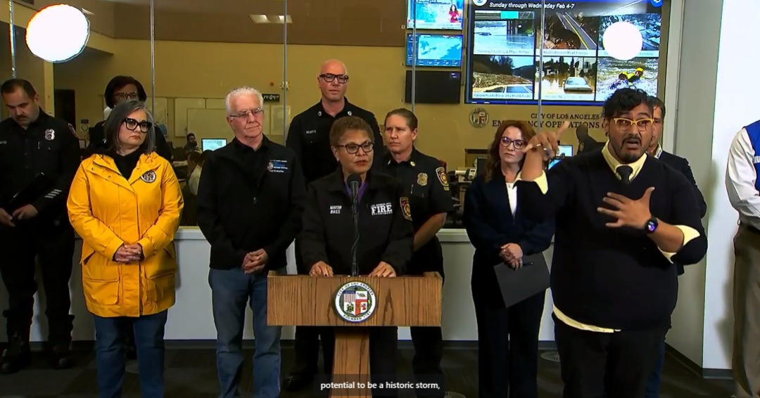
As of the morning of February 4, the National Weather Service of Los Angeles has updated the warnings about the storm system that is about to descend on the county of LA. The weather pattern has shifted to center more on Los Angeles. The NWS has upgraded the time period with high risk for life-threatening and damaging flooding for two days, from Sunday through Monday. In a press conference this morning with multiple agencies, Mayor Karen Bass stressed that the city will engage in an “all hands on deck” effort.
In an update as of 4:15 p.m. on Sunday, a flash flood warning is in effect for the following communities: Malibu, Beverly Hills, Hollywood, Santa Monica, Culver City, and Venice. The warning will not expire until midnight. The warning states, “At 3:41 p.m. PST, Doppler radar and automated rain gauges indicated heavy rain showers overspreading the warned area. Between 0.5 and 2 inches of rain have fallen. Additional rainfall amounts of 1 to 4 inches are possible in the warned area. Flash flooding is ongoing or expected to begin shortly.”
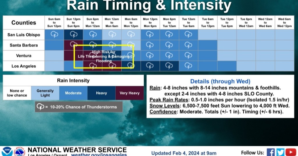
The most substantial change in this weather system is the eastward shift of the heaviest and longest-lasting rainfall, now concentrated over Los Angeles County. This robust atmospheric river is set to make its presence felt today, promising heavy rainfall, potential flash flooding, and high-elevation mountain snow across much of the region through Tuesday morning. Subsequent to this powerful storm, the area can expect lingering showers and a drop in snow levels throughout the week.
Authorities are strongly urging residents to take this storm seriously and heed evacuation orders as the storm brings major threats to life and property. A multitude of roads and freeways are anticipated to flood or close, with canyon roads facing the risk of significant rockslides.
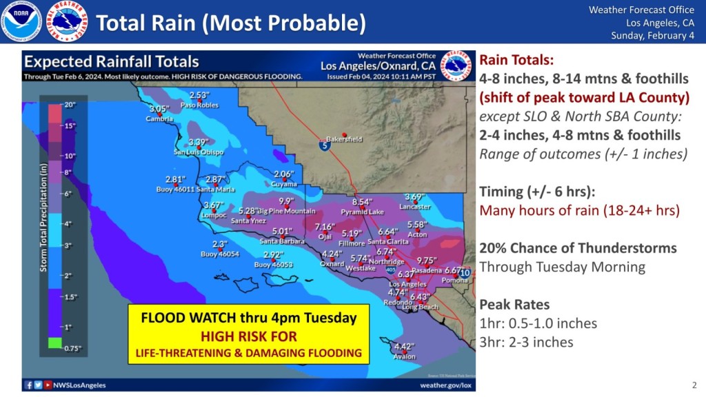
Low-lying neighborhoods may witness waters breaching curbs, with one to two feet of water infiltrating vulnerable homes and businesses. Parked cars are at risk of damage, and mudslides are likely in susceptible areas, especially those with recent burn scars. Creeks are expected to overflow, posing drowning risks to anyone in their channels, including those without shelter or camping. Los Angeles Fire Department stations are offering free sandbags to residents.
The forecast for the next few days is as follows:
This Afternoon
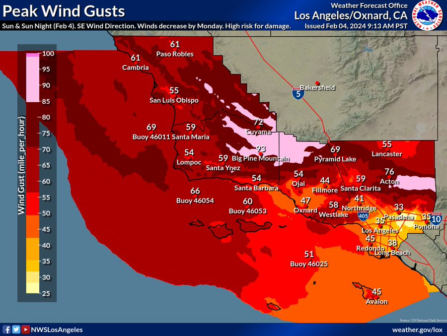
Rain. The rain could be heavy at times. High near 60. Breezy, with a southeast wind of around 20 mph, with gusts as high as 30 mph. The chance of precipitation is 90%—new precipitation amounts between a half and three-quarters of an inch possible.
Tonight
Rain, with thunderstorms, is also possible after 10:00 p.m. Some of the storms could produce heavy rainfall. Low around 53. Breezy, with an east-southeast wind of 15 to 20 mph, with gusts as high as 35 mph. The chance of precipitation is 100%. New rainfall amounts between 2 and 3 inches possible.
Monday
Rain and possibly a thunderstorm. High near 60. Southeast wind around 15 mph, with gusts as high as 20 mph. The chance of precipitation is 100%. New precipitation amounts between 1 and 2 inches are possible.
Monday Night
Rain. Low around 51. East wind 5 to 10 mph. Chance of precipitation is 100%—new precipitation amounts between a half and three-quarters of an inch possible.
Tuesday
Rain. High near 59. East wind 5 to 10 mph becoming south in the afternoon. The chance of precipitation is 90%—new precipitation amounts between a half and three-quarters of an inch possible.
In urban areas, the potential for falling trees is a concern, which could result in power outages anywhere in the region. The City of Los Angeles and NWS urge motorists to use caution when they see a flooded road since waters can be much deeper than they appear, and there is a chance of getting stuck or being swept away when you drive into a flood.
https://x.com/NWSLosAngeles/status/1754262270329475381?s=20
Another caution from the City is to avoid downed power lines and downed trees, which could conceal downed power lines that may still have power coursing through them and present a potentially fatal danger. To find or report outages, you can go to DWP.com.
Mountain communities above 6,000 feet may face isolation due to heavy snow covering access roads, potentially lasting for a day or two. Extremely hazardous sea conditions are anticipated over open waters and along the coastline, with very large and steep waves posing additional risks.
Residents are strongly advised to heed any evacuation orders and to stay off roads, especially freeways, from this afternoon through at least Monday morning.
The City of Los Angeles has activated its alerting systems for localized issues of significant impact during winter storms when authorized. Residents in immediately affected areas, particularly those subscribed to NotifyLA, will receive directed information with specific actions to take and where to turn for timely updates.
To receive all-weather critical alerts for your area, register for NotifyLA. In case of possible life-threatening storm-related emergencies, Angelenos should contact 9-1-1. For other impacts, such as mudslides, street flooding, or fallen trees, call 3-1-1.
Residents are encouraged to save time by accessing most LA City services online or downloading the MyLA311 cellphone app.
Residents are urged to listen and watch for warning signs, such as mud buildup at the base of hills, widening cracks in outside walls or paved areas, sticking doors, newly broken utility lines, and new pools of groundwater. These indicators can help identify potential hazards and ensure a swift and informed response to mitigate risks.

